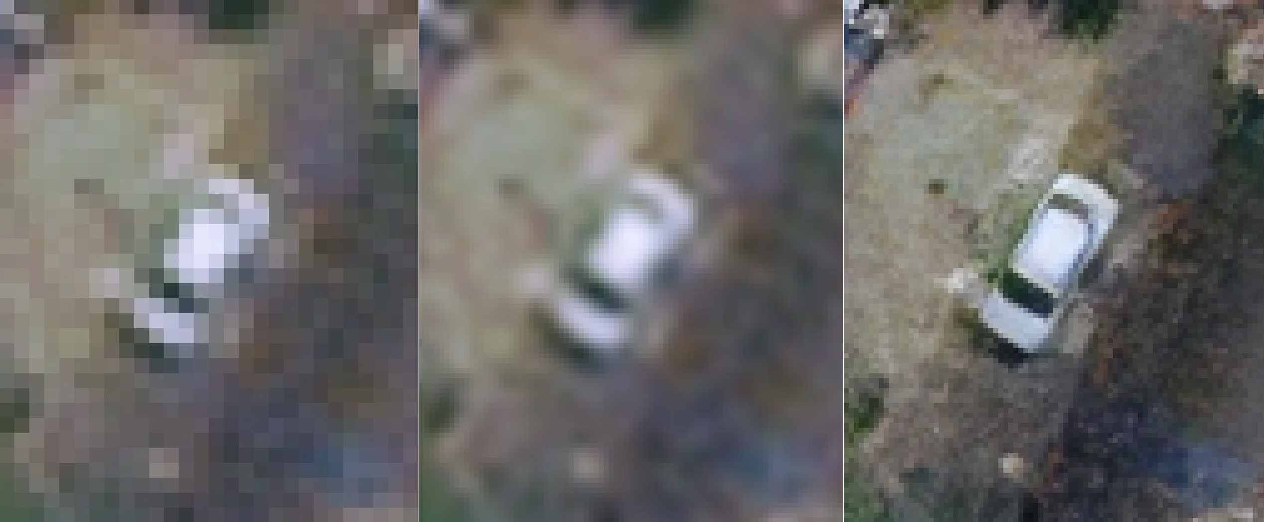
WorldView-3 · 30 cm native · 3× Clarsat HD10 enhancement

What your pixel grid buried, our model reveals.

Measurable optical detail, recovered from imagery you already own.

GSD is set by your optics — no algorithm changes that. Clarsat changes how much of it you can read.
Run It on Your Scene Discuss Partnership

Free account · your own imagery · no card.

WorldView-3 30 cm enhancement comparison: nearest, bicubic, Clarsat HD10
Native 30 cm input. Identical crop. No hand-tuning.

Detail that turns into decisions

From “something changed here” to “this is what changed.”

Monitor and identify

Track high-value assets, infrastructure condition, and agricultural change over time — across regions where putting an aircraft or a field team on site is slow, costly, or simply not an option.

Map and verify features

Light poles, signs, road markings, building edges, individual parcels. Features that arrive as a handful of ambiguous pixels come back distinct enough to digitize.

Lift detection accuracy

Higher precision for downstream object detection and classification models. The same inputs your stack already consumes, with edges the pixel grid had smeared together now separable.

Optical enhancement, engineered for measurement

Single-image enhancement for EO optical imagery, at 2× and 3×. No temporal stack, no auxiliary sensor required.

Two working scales

2× and 3× enhancement. A 30 cm native scene comes back carrying detail equivalent to 15 cm and 10 cm sampling. Pick the factor your downstream task actually needs.

EO-native

Tuned for optical imagery and tested against WorldView, SPOT, KOMPSAT, and Sentinel-2 scenes. Multispectral products are accepted whole — the model enhances the visible bands and carries the rest through to the output.

Integrity-preserving

Geometric and radiometric integrity maintained. The analytic GeoTIFF comes back georeferenced, with pixel values your measurement chain can still consume.

Evaluating for a product line? The same model ships three ways — hosted API, on-prem container, or licensed weights.

Test it on your own scene

Free, no credit card. Upload an EO scene, run 2× or 3×, and put the output through your own checks.

  • Your own imagery · ROI up to 512×512 px — about 150 m across at 30 cm
  • Five 256×256 tiles per rolling 24 hours, no card required — one 512×512 run spends four of them
  • Keep the output — PNG and JPG previews carry a Clarsat mark; the GeoTIFF does not, so your measurements stay clean

Larger ROI, batch runs, watermark-free previews, and production throughput come with a partnership plan.

Already know what you need? Go straight to a partnership conversation.

Partnership models

Three ways to put Clarsat into your pipeline. Pick the one that fits your data and your stack.

API Integration

For evaluations and low-volume production

Send a tile, get a result. Hosted on our infrastructure. The fastest path to early evaluation and pilot integrations.

Weights Licensing

For vendors with their own inference stack

Model weights and integration support. Drop into your runtime, your serving. Long-term licensing, no per-call charges.

Frequently Asked Questions

Does my imagery leave my environment?

For try-on and API evaluation, scenes are processed on our infrastructure, and you can delete any scene and its outputs from your account at any time. For imagery that cannot leave your environment at all, choose the on-prem container or weights licensing — your data stays where it is.

Can I run it on my own scene?

Yes. Create a free account and run the model on your scene immediately — ROI up to 512×512 px, on a free allowance of five 256×256 tiles per rolling 24 hours. For larger evaluation runs, request access via the partnership form.

What sensors are supported?

EO optical imagery today — RGB, and the visible bands of multispectral products, with the remaining bands carried through to the output. Tested against WorldView, SPOT, KOMPSAT, and Sentinel-2. IR, SAR, and panchromatic models are in development; tell us what you fly and we will tell you where it stands.

Can we benchmark privately under NDA?

Yes. We provide standard partnership NDAs and can run reproducible benchmarks on your validation set. Indicate this when you contact us.

Which scale factors are available?

2× and 3× for EO imagery. 4× is in development — if your evaluation depends on it, say so in the form and we will tell you the timeline.

What does pricing look like?

Partnerships are negotiated case by case, based on throughput and deployment model. Tell us your expected volume and target deployment, and we will come back with a concrete number.

Does Clarsat increase GSD?

No — ground sampling distance is set by your sensor's optics, and no algorithm changes that. What Clarsat does is recover detail buried by pixel-grid limitations and conventional resampling, so that what the optics already captured becomes readable.

Discuss partnership

Tell us about your imagery and integration target. We reply within two business days with a concrete next step.

EO is in service today. Telling us the rest is how we decide what ships next.
Thanks — your inquiry has been received. We'll come back to you within 2 business days.
We couldn't submit your inquiry right now. Please email contact@clarsat.com directly or try again shortly.

Prefer email? Write to contact@clarsat.com. We use what you send here only to answer your inquiry.